Tornado Watch Issued Until 7 p.m.

The National Weather Service has issued a Tornado Watch until 7 p.m. tonight for Baltimore County and most of central Maryland,  Storms that form this afternoon may have tornadoes or damaging winds.
Baltimore County Emergency Management encourages resident to have three of ways communications to receive warnings and have a shelter location picked out to use IMMEDIATELY after a warning is issued.
Baltimore County Public Schools announced that all schools will be closing three hours early today for inclement weather.

Baltimore County Schools to Close Early


Baltimore County Public Schools announced that all schools will be closing three hours early today for inclement weather.

Strong thunderstorms are expected this afternoon and into the evening as the remnants  of Hurricane Ida pass through the region.

Below is full state from BCPS:

“Due to impending inclement weather, Baltimore County Public Schools, the Virtual Learning Program, and offices will dismiss three hours early on Wednesday, September 1, 2021. All afterschool and evening activities are also cancelled. No afternoon PreK. “Essential” employees remain on duty or may request from the appropriate supervisor to use leave time. “Essential as Needed” employees will remain on duty as directed or may request from the appropriate supervisor to use leave time.”

Lighting Causes Parkville Apartment Fire


-photo courtesy of Providence Volunteer Fire Company of Towson Maryland Facebook page-

Baltimore County Emergency Crews had a busy day as a result of the strong storms in the area on Saturday, July 7.

Baltimore County Fire Department reported a two alarm condo fire in the 2200 block of Lowells Glen Road in Parkville.

The fire was reported through the roof. Crews evacuated tenants and pets. Everyone got out safely. No injuries were reported. The fire started before 3 p.m.

Investigators have confirmed this fire began with a lightning strike.

Tree Damages Two Essex Apartment Buildings


There have been multiple reports of damages from the storm throughout the day.

Another area that saw storm damage was Essex.

The Baltimore County Fire Department reported a tree heavily damaged the two apartment buildings in the 900 block of Garden Drive on Saturday afternoon.

Several families were displaced. No injuries were reported. Building engineers and the RedCross responded to the scene.

Flooding Causing Major Issues on Pulaski Highway

Water rescued from car & propane leak at building on Pulaski


-photo courtesy of White Marsh Volunteer Fire Company-

The Baltimore County Emergency Management Twitter page reports several water rescue calls along Pulaski Highway in the Rosedale area. Other roads on the east side of the county are also flooded.

The Baltimore County Volunteer Fireman’s Association reported that a vechile was trapped in floodwater and two people were rescued on Pulaski Highway near Contractor Road on Saturday around 4:15 p.m.

The Fireman’s Association also reported a propane leak at a building in the 7800 block of Pulaski Highway.

Motorists are being told to -AVOID Pulaski Highway and find another route.

There is a Flood Warning for most of Eastern Baltimore County until 6:30 p.m.

The County reminds motorists to not drive into high water on any roads.

If you see a flooded road, turn around!

Another Round of Thunderstorms Forecasted for Area


The US National Weather Service Baltimore/Washington is calling for an enhanced risk of severe thunderstorms in Baltimore County and central Maryland on Monday, June 21.

The US National Weather Service Baltimore/Washington’s best estimate for storm timing this afternoon is between 5 to 7 p.m. for Baltimore County.

The Baltimore County Emergency Management added that damaging winds are possible if a severe thunderstorm warning is issued and citizens need to know where to shelter to protect themselves from falling trees.

Severe Weather Forecasted for Saturday Night


The National Weather Service Baltimore Washington reports that the risk for severe weather has been expanded to the south and west as shown in the graphic.

Late afternoon to evening thunderstorms could bring a risk for damaging winds, large hail, and perhaps an isolated tornado.

Uncertainty is a bit higher than usual with storm development.

Bad Storm Damage Reported in Edgemere Area


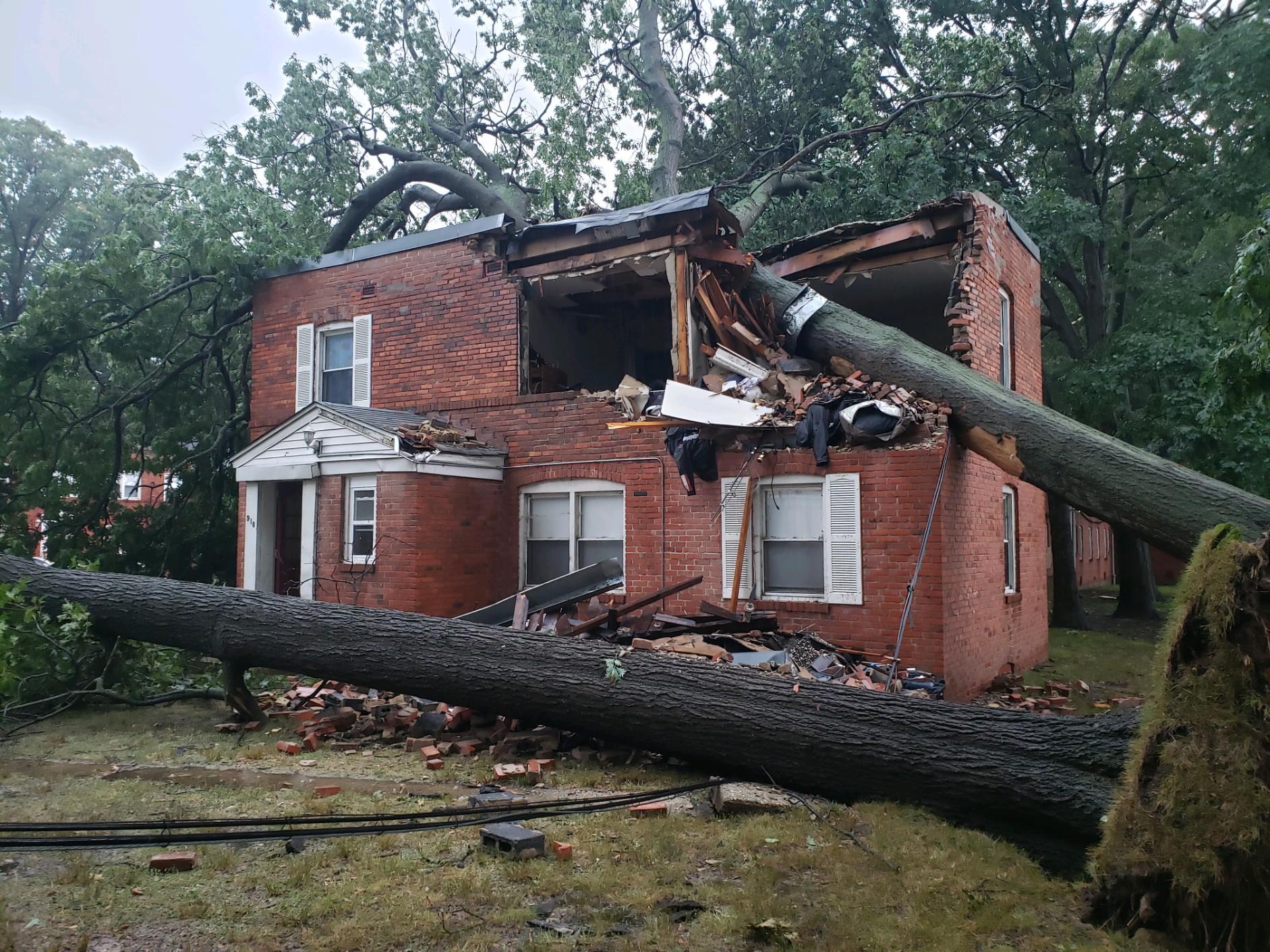
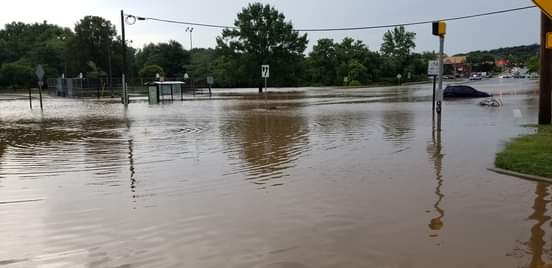
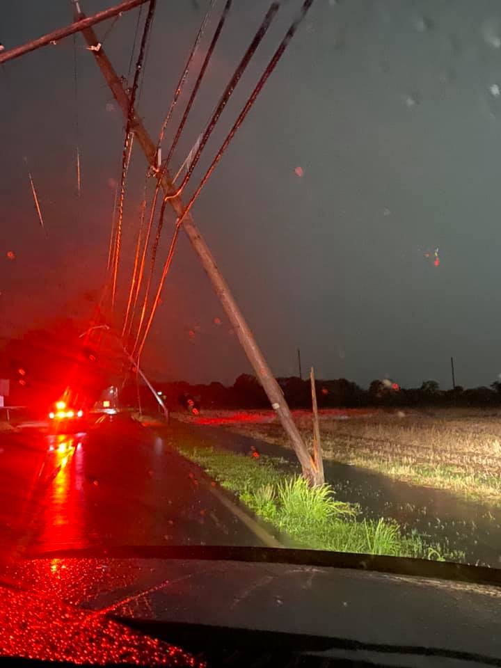
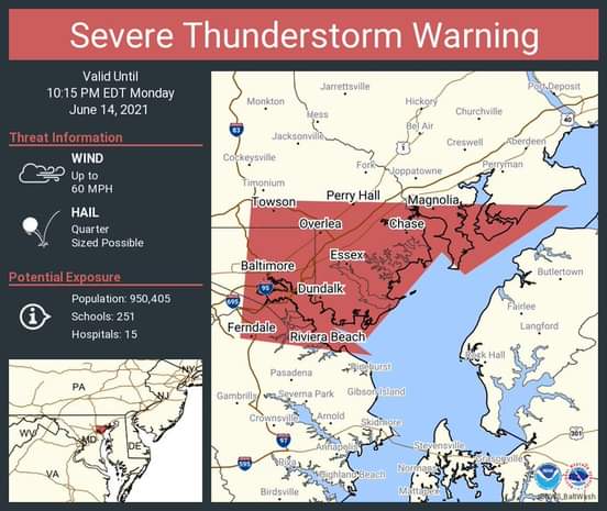
The North Point Edgemere Volunteer Fire Department [NPEVFD] reported that a strong storm on Monday, June 14 resulted in 18 service calls in the North Point Peninsula area.

Some of those calls included down trees, down powerlines and flooding.

One of those calls sent the Baltimore County Marine Unit to rescue two boaters who were stranded near the Fort Howard Lighthouse after their boat was overtaken by bad weather.

The boaters were rescued in what was described as “extremely rough sea conditions”.

It was reported that all crew members returned back safely.

“Last night the North Point Peninsula community experienced mother nature at her worst,” said a statement from the NPEVFD Facebook page.

Some in the area have questioned if this storm was a tornado. The National Weather Service has not yet confirmed if Monday’s storm was a tornado but the NPEVFD said the storm appeared to have a “rotation”

“The crew entered into the first storm cell, which was indicative of some rotation, while the events are still being investigated by the NWS, it is hard to deny rotation of this storm,” said a statement from NPEVFD.